One of the most useful bits of information you can attach to an image is the location where a photo or video was taken. This information can be used in many different ways. It helps us find images, it tells us something about the subject matter, and location tags can be a key to lots of other information. There are two primary ways to tag an image location:
- IPTC metadata can include human-readable place name tags.
- GPS information provides machine-readable mapping coordinates.
IPTC Location Tags
The original IPTC location tags were added to the specification in 2004 and include Country, State or Province, City and Sublocation. These human-readable, informative and hierarchical tags are an extremely useful tool in making sense of an image collection. In many cases, they are easy to classify and fill out, but there are some exceptions which can add a few wrinkles.
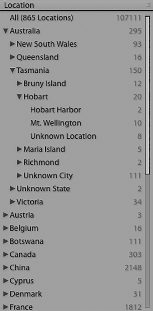
The IPTC location tags are (mostly) straightforward and quite useful. In Lightroom and other programs, you can browse through the tags, sorting through state and city tags down to the exact location. The natural hierarchy of the tags allows them to be navigated easily, even for a large and diverse collection.
Ambiguity in sub-location
The top three fields are often pretty easy to fill in, but the exact location of the photo – the sub-location – often requires a judgement call. You might want to use the neighborhood, building address, or a more descriptive term like “Silas Pickering’s apartment.” In general, I suggest that you use a sub-location that is most useful to you and the other stakeholders of the collection. A street address, for many people, is less useful than the name of the building, business, or person who lives there.
While it would be technically correct to tag the location as 40 E. 88th St. New York, it’s much more relevant to tag the sub-location as Silas Pickering’s Apartment.
Other ambiguity
There are times when your location does not fit inside this neat hierarchy. You might be at sea in international waters, or on a river that divides two states. Or perhaps you are in a national park that crosses state lines, and you are not sure which state you are in. In cases like these, it’s probably best to pick a general practice and stick to it. And in these instances, GPS information may really be the best solution.
Camera location does not match location shown
It’s also possible that you might shoot from a location that is entirely different from the one shown (e.g., shoot a picture of New York while standing in New Jersey). In general, it’s best to tag for what’s shown. The photo at the top of this post is an example. It was shot from Zambia, but mostly shows Zimbabwe.
The IPTC Extension includes location namespaces which can be used to specify both the camera location and the location shown. In creating the new fields, the IPTC organization has designated the old location fields as Legacy.
While this could be really useful for some people, it does not appear to be widely adopted. Worse, this means that there are three places where the information can be written, with the most widely used fields now listed as “Legacy.” And the new fields are not very widely supported. This looks like a case where the solution to the edge-case problems has made the overall problem harder to solve.
In the next post, we will look at GPS location data and see how it can help with precision, tagging automation and better workflow.